
The Meteora is one of the largest and most important complexes of Greek Orthodox monasteries in Greece, second only to Mount Athos.
The Meteora literally means “middle of the sky“, “suspended in the air” or “in the heavens above”
In the Byzantine times, monks had the inspiration to construct monasteries on top of these rocks so that they would be closer to god.
The rock masses were formed some 60 million years ago, their distinctive and varied shapes sculpted over time by earthquakes, rain, and wind.
Rising high above the Thessalian plain, the sandstone megaliths on which the monasteries were built average 300 metres (1,000 feet) in height, with several reaching 550 metres (1,800 feet).
The foundation of Meteora monasteries began around the 11th century. In the 12th century, the first ascetic state was officially formed and established a church to the Mother of God as their worshiping centre. Activities on this church were not only related to worshiping God, but hermits used these occasions to discuss their problems and exchange ideas relating their ascetic life there.

Although 24 monasteries were built, each containing a church or two, monks’ cells, and a refectory, only 6 remain: Great Metéoron, Varlaám , Roussanou, St. Nikolas , Holy Trinity , and St. Stephen .
In the 14th century, Saint Athanasios Meteorites, a scholarly monk from Mount Athos established the Holy Monastery of the Great Meteoron and named this huge rock Megalo Meteoro, which means Great Place Suspended in the Air. This monastery is also known as the Holy Monastery of the Transfiguration of Christ and it is the highest, largest and oldest of the six monasteries of the Meteora.
holy monastery of the great meteoron
The frescoes of the katholikon date from 1497-98 and are well-preserved. They are painted in the Macedonian style.
holy monastery of the great meteoron frescoes
The Holy Monastery of Varlaam is the second largest monastery in the Metéora complex. It was built in 1541 and embellished in 1548. A church, dedicated to All Saints, is in the Athonite type (cross-in-square with dome and choirs), with spacious exonarthex (lite) is surrounded by a dome. It was built in 1541/42 and decorated in 1548, while the exonarthex was decorated in 1566.

holy monastery of varlaam
Its frescoes were painted by post Byzantine iconographer Frangos Katelanos.
holy monastery of varlaam frescoes
The Holy Monastery of Roussanou was founded in the middle of 16th century and decorated in 1560, the easily-accessible The Holy Monastery of Roussanou Monastery occupies a lower rock than the others of the Meteora. Rousannou Monastery was founded around 1545 by Maximos and Ioasaph of Ioannina. The reason for the monastery’s name is not known – it is actually dedicated to St. Barbara.
holy monastery of roussanou
 The frescoes in Roussanou’s Church of the Transfiguration of Christ, which is essentially a smaller version of Varlaam’s church, date from 1560.
holy monastery of roussanou frescoes
Founded in the early 14th century, Agios Nikolaos Anapaphsas is a monastery in the Meteora notable for its unique construction.
holy monastery agios nikolaos anapaphsas
Splendid frescoes by the 16th-century Cretan painter Theophanes the Monk.
holy monastery agios nikolaos anapaphsas frescoes
The only monastery in the Meteora visible from Kalambaka,the Holy Monastery of St. Stephen’s was founded around 1400. It has a small church built in the 16th century and decorated in 1545. This monastery rests on the plain rather than on a cliff. It was shelled by the Nazis during World War II who believed it was harboring insurgents and was abandoned. Nuns took it over and reconstructed it.
holy monastery of st stephen
The old katholikon, which was rebuilt in 1545 and frescoed shortly thereafter, still stands. The new
katholikon of Agiou Stefanou was built in 1798 and is currently being frescoed by a modern artist.
holy monastery of st stephen frescoes
The Monastery of Holy Trinity is very difficult to reach. The visitor has to cross the valley and continue high up through the rock before we arrive outside the entrance. The church is in the cross-in-square type with the dome based in two columns, built in 1475-76 and decorated in 1741. The spacious barrel – vaulted esonarthex was founded in 1689 and decorated in 1692. A small skeuophylakeion was added next to the church in 1684.

holy monastery of holy trinity
The frescoes in the church date from the 18th century and the those in the narthex from the 17th; they have been well restored.
holy monastery of holy trinity frescoes
U.N.E.S.C.O has characterized the Holy Meteora as a “monument of Humanity that has to be maintained“. They don’t belong only to Greece but also to the entire world. The monasteries of the Meteora are included in the Monuments of world cultural Heritage, because they are a unique harmonious matching of Byzantine architecture and natural beauty.
The buildings of the monasteries seem like a continuance and a natural ending of the rocks. They are a
priceless artistic and heirloom treasure. Moreover, the presence of many monasteries in such a small place, as well as the Orthodox spiritual life and exercise have provoked the admiration and the interest of people all over the world.

Mount Fuji located on Honshu Island, is the highest mountain in Japan at 3,776.24 m (12,389 ft).
This volcanic mountain is actually three separate volcanoes, one on top of the other. The bottom layer is the Komitake volcano, then the Kofuji volcano, then Fuji, which is the youngest of the three.
A pilgrimage site for centuries, it’s considered one of Japan’s 3 sacred mountains, and summit hikes remain a popular activity.
Mount Fuji, one of the world’s most beautiful mountains, is Japan’s most popular attraction.
A perfectly symmetrical volcanic cone, the mountain is a near-mythical national symbol immortalized in countless works of art.
Symmetrical shape is unusual for a mountain, and especially a volcano.

mount fuji from air
Mount Fuji is called Fuji-san in Japanese. The origin of Fuji’s name is disputed. Some say it derives from the Ainu language used by the Japanese aboriginal people and means “everlasting life.” Linguists, however, say that the name is from the Yamato language and refers to Fuchi, the Buddhist fire goddess.
The native Ainu revered the great peak. Shintoists consider the peak sacred to the goddess Sengen-Sama, who embodies nature, while the Fujiko sect believes the mountain is a being with a soul. A shrine to Sengen-Sama is on the summit. Japanese Buddhists believe the mountain is the gateway to a different world.
mount-fuji
The last eruption of this volcano started in December of 1707 and continued until the first day of the new year in 1708.
 The mountain formed in four phases of volcanic activity which began 600,000 years ago.
Mount Fuji is stratovolcano (also known as a composite volcano) that means it is a conical volcano built up by many layers (strata) of hardened lava, tephra, pumice, and volcanic ash.
Mount Fuji Is Surrounded by 5 Lakes! These lakes are called Kawaguchiko, Yamanakako, Saiko, Motosuko and Shojiko. These lakes are around 300 meters (1,000 feet) above sea level and provide people visiting the area with the best vantage point from which to view Mount Fuji.
Sometimes you can see lenticular clouds over Mount Fuji.
lenticular clouds over mount fuji
The Mountain Is Actually Part of a National Park called Fuji-Hakone-Izu. This is the most visited national park in the country.
In ancient times Samurai warriors trained here, and it has also been a site for Buddhist training.
An anonymous Buddhist monk was the first one to climb Mount Fuji in the year 663.
It was forbidden for women to climb Mount Fuji until 1912.
More than 200,000 people climb to the summit every year.
mount fuji summit
Springtime is perhaps the most beautiful time of the year to see Fuji. The snow-covered mountain is framed by pink cherry blossoms, giving Fuji the name Konohana-Sakuahime, which means “causing the blossom to brightly bloom.”
If you plan on climbing Mount Fuji the season is very short. Climbing season begins on the first day in July,and it ends in the last week of August on the 27th.
The sunrise from Mount Fuji has a special name, Goraiko.

Sagano Bamboo Forest is located in Arashiyama, a district on the west outskirts of Kyoto Japan. It covers a total area of 16 sq. kms. It is one of the most attractive natural environments in entire Japan. The forest got stunning natural beauty and the sound the wind makes as it blows through the thick Bamboo Grove, it is sounds amazing. Sagano Bamboo Forest is one of the most amazing natural sites in Japan.
One of the most interesting facts about Sagano Bamboo Forest is the sound which the wind makes while it blows amongst the bamboo. Amazingly enough, this sound has been voted on as one of the “one hundred must-be-preserved sounds of Japan” by the Japanese government. As mentioned he Sagano Bamboo Forest is not too far from Kyoto’s main streets and 30 minutes by train. Another interesting fact the railing on the sides of the road is composed out of old, dry and fallen parts of bamboo.

The area has been a popular destination since the Heian Period (794-1185), when nobles would enjoy its natural scenery. Arashiyama is predominantly popular during the cherry blossom seasons and fall color seasons. Within this area lies the famous bamboo forest of Sagano. There is a walking path that cuts through the bamboo grove making for an enjoyable and popular trek. When the sun is shining and there’s a gentle breeze to cause the trees to sway, the setting becomes quite attractive.
The bamboo forest in this grove is still used to manufacture numerous products like as cups, boxes, baskets and mats in the area. Several travelers online have mentioned that the bamboo forest path can get quite busy. Hopefully if you visit this beautiful area, it’s not too busy so you can pause to admire the beauty and tranquility of this distinct place. WOW! It’s really inspiring and a very awesome place to see. Everyone must have a wish to visit it personally with some of your friends. This forest is not only so attractive but also a play a main role in Japan economy.

Moreover; you know Bamboo has several advantages, it is a big source of their trade also and beautiful scene to see. Bamboo Forest is a sounds really a cool place to visit in Japan. Such kind of unique places attract everyone a lot. The Bamboo Forest Kyoto, Japan is the best place to enjoy the hiking trip. The tall bamboos are very impressive and attractive. Bamboo forest has a long path to walk. Many people do the walking along this path, and there are many points that you can stop to see such as temples, etc.
Only 30 minutes or so from the bustling Kyoto city center, the towering bamboo forest is an almost shocking contrast to the urbanity surrounding it. Wooden paths weave through the dense thicket of tall bamboo stalks that reach dozens of feet into the sky, creating a canopy. The absolutely gorgeous forest of skinny bamboo trunks is the heroin chic of wooded glades. As the wind passes through the tightly packed plants, the wood bends and creaks, the leaves rustle, and the trunks knock together, creating a peaceful sound like almost nothing else. That is when the hordes of tourists aren’t drowning it out.

The meditative natural noise is so lovely in fact that Japan’s Ministry of the Environment voted the locations aural pleasures as one of the country’s “100 Soundscapes of Japan,” an initiative designed to get the local population to get out and appreciate the wonders of the ears. If visitors can find a time to visit the bamboo forest when it is relatively empty the combination of visual beauty and auditory calm may be one of a kind. There is no word however on how the place smells.

The unique landscape of Cappadocia was formed by the erosion of volcanic rocks. Ancient volcanic eruptions blanketed this region with thick ash, which solidified into a soft rock called tuff. Over time wind and water eroded these tuff rocks, turning them into mushroom-like pillars known as fairy chimneys.
The soft quality of tuff rocks in Cappadocia enabled the early inhabitants to carve dwellings, churches, and hiding places both above and under the ground which make up one of the largest rock-cut complexes in the world.

Cappadocia covers an area of approximately 5,000 square kilometers and lies between three provinces in Central Anatolia; Nevşehir, Keyseri, and Niğde, right in the heart of Turkey.
During the ancient times the Cappadocia region was famous for its horses. It is believed that the name “Cappadocia” is derived from an ancient Persian word, “Katpaktukya” which means the land of beautiful horses.
Özkonak underground settlement is different from other underground cities in the region because of its defensive features. Özkonak contains small holes on its ceiling which are believed to be used for pouring oil onto intruders.

Because of Cappadocia’s dry and arid landscape, farmers used Pigeon droppings to fertilize their land. Every able bodied male was expected to dig himself a pigeon house on top of formations away from predators and thieves.
The Christians, escaping the Arab invasion, gave one town the name of Goreme which means “you cannot see here”.
A monastic life in Cappadocia was established by Saint Basil the Great or Basil of Caesarea who encouraged Christian monks to gather and pray together in a monastery.

Tokali Kilise church, also known as the Buckle Church, is considered to be the main sanctuary of monastic life in Byzantine Cappadocia. The frescoes in Tokali Kilise church represent some of the finest surviving paintings from the early Middle Ages.
There were two types of painting techniques used in churches of Cappadocia. The first technique is to paint directly on the bare rock using roots of vegetables for color. Later on these original paintings were covered with plaster and repainted with scenes from the bible.

1. Irish hermit monks, are now thought to be the earliest settlers of the Faroe Islands. They arrived in the sixth century, bringing with them sheep as well as early Irish language. The Vikings landed by 900AD.
2. The Faroe Islands, formed by volcanic activity 30 million years ago, are now a cultural melting pot with 77 nationalities among its population of only 48,000.

3. The Faroe Islands are one of very few countries in Europe to have no McDonalds outlets. You can, however, find a Burger King, in Torshavn if you're in need of a fast food fix.
4. The country's football team won their first competitive match against Austria in September 1990, which prompted a massive Faroese party.
5. There are three traffic lights on the Faroe Islands. All are in the capital Torshavn and are very close to each other.
6. Crime doesn't appear to be rife. There is no prison on the Faroe Islands and any long-term prisoners get sent off to Denmark.

7. Streymin bridge is the only bridge over the Atlantic Ocean in the world, connecting the island Streymoy to Eysturoy.
8. The Faroese language, spoken by all Faroese people, is most similar to Icelandic and the now extinct Old Norse language. English is also widely spoken, especially among the younger people.
9. Not sure where the Faroe Islands are exactly? They lie northwest of Scotland and halfway between Iceland and Norway. It is composed of 18 individual islands covering 545 square miles, 70 miles long and 46 miles wide, roughly in the shape of an arrow-head. On the islands you are never more than three miles from the ocean.
10. Star player Gunnar Nielsen, a goalkeeper for the Scottish team Motherwell, is the only footballer from the Faroe Islands to play in a Premier League. Manchester City is among his former clubs.
11. Birdwatching is popular. There are many puffins to see – around 10 times as many as there are humans – plus oystercatchers and other rare birds.
12. Your most likely company out and about is sheep. Some farmers have started putting reflective straps on their sheeps' legs so they won't get run over in bad weather and poor visibility.
13. The Faroe Islands are not far from the southern end of the Arctic Circle. Considering their high latitude, the islands are not as cold as you might expect, with average temperatures of 3C in winter and 11C in summer.
14. Considered to have a 'fairytale' landscape, the Faroe Islands are covered by a blindingly green grassland that carpet the islands from the base up to the highest mountains, although few trees survive because of the North Atlantic winds.
15. National Geographic recently elected the Faroe Islands as the world's most appealing island community, out of 111 island destinations worldwide. They are noted for their friendliness.
16. The weather in the islands changes so quickly and frequently that a well-known Faroese saying is 'If you don't like the weather, wait five minutes'.
17. The Faroese drink in sheebeens, known as key clubs – set up in secret when alcohol was banned on the islands. These dens were so popular they stayed open when prohibition ended. There is an Irish pub called, imaginatively, 'Irish Pub'. It is said to serve the best beer on the islands.

18. One of the Faroes' best football results came in September 2002. They raced into a 2-0 lead against Scotland, before their opponents fought back for a draw. The result was a major embarrassment to Scotland. One headline read: 'Faroes 2 Fairies 2'.
19. Fishing is the islands' single most important industry, providing more than 97% of the total exports. The second largest industry, perhaps surprisingly, is tourism.
20. The Faroes are a self-governing community within the Kingdom of Denmark.
Five fun facts about the Republic's opponents Gibraltar

1. Gibraltar has the only wild monkey population in the European continent, and the monkeys are thriving. But whatever you do, don't feed them – you could be slapped with a £4,000 fine. The free-roaming and tail-less barbary macaques make occasional forays into town where they run amok foraging in rubbish bins and harassing locals.
2. Legend has it that Gibraltar will cease to be British if the monkeys leave. This legend was taken very seriously by the British Government, so much so that the Army used to be responsible for their care. However, this week Gibraltar rounded up its 30 most troublesome monkeys for a new life in a Scottish safari park.
3. The official language is English, but Gibraltar has its own peculiar dialect – a blend of English, Spanish, Genoese and local words. The common name for the dialect is 'llanito' and locals are known for passing seamlessly from English to Spanish at lightning speed.
4. Gibraltar was used as a location in the 1987 James Bond movie The Living Daylights. The scene filmed saw James Bond and other agents parachuting from a plane on to the Upper Rock .
5. The tiny colony may be one of the smallest countries in the world, with a population of just 30,000, but it is considered one of the most prosperous places in Europe to do business. M&S, Morrisons and Next also all operate on Gibraltar.

If in search of your next big adventure, Donsol is the right stop. This small town found at the southern tip of Luzon Island, Philippines, knows what a big adventure is all about. Have you ever imagined swimming beside a huge fish that is 18 meters (50-60 feet) long and 40 tons heavy? Now, imagine swimming with a school of fishes that big! That is what Donsol has to offer.
Donsol is the world’s most reliable place to view and interact with whale sharks as they travel through between November and May.
Whalesharks are believed to be the only remaining member of their prehistoric family. In fact they are believed to have dwelled the waters for some 60 million years!
Whalesharks are found in pockets of warm, tropical water and grow more than 12 metres long and weigh more than 11 tonnes.
Being a rare and mysterious creature, only minimal information has been discovered about whale sharks.

The Whale Shark, the biggest fish in the world, finds refuge in the waters of Donsol from november to May. With snorkeling equipment, you will be awestricken by the grandeur of these animals. If you doubt your swimming skills, Just slip on a life vest! The Whale Sharks swim from surface to mid-water and with their size, they are hard to miss. The Whale Sharks are friendly to human beings and they will love your admiration. Just remember not to scare them away by touching or harassing them. Give them the respect they deserve, and they will make sure that your visit will be one that is worth a lifetime!
The Whale Shark, Rhincodon Typus, is included in the list of endangered species. There are only about 1000 identified Whale Sharks worldwide. Despite the fact that studies trace the history of the Whale Shark to be 245-265 million years back to the Jurassic and Cretaceous periods, the enormity of these fish, and the fact that they swim at the ocean surface, the first known Whale Shark to man was discovered in 1828.

As the study of the Whale Shark developed, it is said that the largest annual congregation of the Whale Sharks is in Donsol, Philippines from november to May. These so-called gentle giants are migratory animals, found in warm tropical waters as they follow their food supply. They migrate to Donsol in vast numbers to take advantage of the dense food concentration of plankton and krill which is brought about by the current patterns, water temperature, and the general health of the sea.

With the discovery of the immense number of Whale Shark in Donsol and the promotion of eco-tourism in the area, efforts for the preservation of the Whale Shark has been heightened. Scientists and conservationists have also migrated to Donsol to further study these animals. By using tracking devices and photo identification, it is hoped that the mystery of these great gentle giants will be soon discovered.
In Donsol waters, typical sightings of whale sharks are between 4-12 meters in length with distinctive characteristics that include a broad, flat head, 3 prominent ridges on the upper flank, a checkerboard pattern of white spots and stripes on its blue-gray-brown-skin.
Their huge mouth (up to 2m across) is lined with thousands of tiny teeth, which is neither used for chewing not biting. Large volumes of water are sucked into the mouth where the food is retained in the gill rakers Water is eventually released through their gill slits. Whale Sharks are rare and amazing creatures. Swimming with them is an adventure of gigantic proportions.

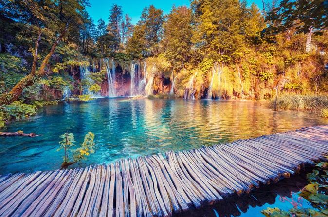
Within the boundaries of this heavily forested national park, 16 crystalline lakes tumble into each other via a series of waterfalls and cascades. The mineral-rich waters carve through the rock, depositing tufa in continually changing formations. Clouds of butterflies drift above the 18km of wooden footbridges and pathways that snake around the edges and across the rumbling water.<br />
It takes upwards of six hours to explore the lakes on foot, or you can slice two hours off by taking advantage of the park's free boats and buses (departing every 30 minutes from April to October). From Entrance 2, catch the bus to the top of the upper lakes and wander back down to the shore of Kozjak, the park's largest lake (about 4km in length). A boat will whisk you from here to the lower lakes, where the circuit culminates in the aptly named Veliki Slap, the tallest waterfall in Croatia (78m). The path then climbs steeply (offering great views and photo opportunities) to a bus stop, where you can grab a lift back to Entrance 2.
 If you've got limited time, the upper lake section can be completed in two hours. The lower section takes about three, although we recommend that you start with the bus ride and end with the boat to save yourself a climb.
Note that swimming is not permitted in any of the lakes.
If you've got limited time, the upper lake section can be completed in two hours. The lower section takes about three, although we recommend that you start with the bus ride and end with the boat to save yourself a climb.
Note that swimming is not permitted in any of the lakes.
The Plitvice Lakes National Park, Croatia’s most popular tourist attraction, was granted UNESCO World Heritage status in 1979. Located roughly halfway between capital city Zagreb and Zadar on the coast, the lakes are a definite must-see in Croatia. (As confirmed by the many emails we’ve received!)
The beauty of the National Park lies in its sixteen lakes, inter-connected by a series of waterfalls, and set in deep woodland populated by deer, bears, wolves, boars and rare bird species. The National Park covers a total area of 300 square kilometres, whilst the lakes join together over a distance of eight kilometres.
 There’s also quite an altitude difference – the highest point is at 1,280m, the lowest at 380m – although the total height difference between the lakes themselves is only 135m. (Veliki Slap, the largest waterfall, is 70m tall.)
If you’re undecided about whether or not to visit Plitvice Lakes, take a look at any photo album of the Park and that will surely sway you! The official Plitvice Lakes website has a fantastic virtual tour that features some truly stunning scenes.
Or, for another prewiew, check out our Plitvice Lakes Photos!
Getting to the Plitvice Lakes National Park
See our page on Getting to the Plitvice Lakes National Park for details on how to get there by public transport or organised excursion.
If you’re driving to the Park, there is parking at both entrances. It costs 7 Kuna per hour for cars.
Visiting the Plitvice Lakes National Park
The Park is open daily all year round, with longer opening hours during summer (usually 7am to 8pm). There’s an entrance fee which acts as a contribution to the Park’s upkeep and protection: for adults it’s 55 Kuna (£5.50/€7.25/$8.50) January to March and in November and December; 110 Kuna (£11/€14.50/$16.50) during April to June and in September and October; and 180 Kuna (£18/€24/$27) in July and August.

Children aged 7 to 18 have cheaper tickets, whilst children under the age of seven go free. Students also get discounted entry, and groups of 15 or more (whether adults, students or children) can also get discounts.
2-day tickets for the Park can also be purchased, which provide you with some cost savings.
4-hour guided tours in English, German, French, Spanish, Italian or Croatian can also be pre-booked for a minimum of 15 people at an additional cost.
There are two entrances to the Park – excitingly titled Entrance 1 for the lower lakes and Entrance 2 for the higher lakes. Entrance 2 (and therefore some of the park) is normally closed in winter (November to April).
Full details of ticket prices can be found on Operating Hours and Prices page of the Plitvice Lakes National Park website.
Plitvice Lakes National Park
Sightseeing in the Plitvice Lakes National Park
See our special page on Exploring the Plitvice Lakes National Park.
The best time of year to visit the Plitvice Lakes
Plitvice Lakes isn’t just for summer. It’s a stunning place to visit any time of year as the different seasons see the Park take on different hues, whether that’s lush greenery in spring/summer, rich colours in autumn, or magical scenes in the snow and ice in winter. Even if conditions are rainy, the park can still be wonderful to explore as the water takes on a dramatic effect – sometimes bubbling up underneath your feet on the wooden pathways!
Understandably, Plitvice can get very busy during summer and the pathways can be quite crowded. We’d ideally recommend a spring/late summer visit when the weather is still good, the park is open for relatively long hours but there should be fewer people.
Do note that the Entrance 2 (lower lakes) is normally closed in winter – but there’s still plenty to explore from Entrance 1.
Accommodation in the Plitvice Lakes
It is possible to stay right next to the Park at one of its three hotels (which are all clustered quite closely together by Entrance 2) or at its campsite, Camp Korana (which contains bungalows or space for 500 camping units), which is about 7km from entrance 1. Another campsite, Camp Borje, is 15km away from Entrance 2. There is another hotel, the Hotel Grabovac, that is also located 12km north of the Park.
There is also a very wide selection of private accommodation (rooms, apartments in guesthouses and similar) in the region. There are some options very close to the park entrances, but also plenty of choice in a number of the towns and villages (such as Slunj) on the way to the Park. If you don’t have your own car, do make sure you pick an accommodation choice that’s walking distance to the Park! (Or perhaps arrange transfer options with the accommodation owners.)
See our Accommodation in the Plitvice Lakes page for a detailed listing of all of the above options.


