
Surrounded by beautiful Lapland scenery, Hotel Kakslauttanen is the perfect winter retreat and base for a fun packed winter activity holiday and a magical visit to see Santa Claus and his elves in the nearby Santa’s Resort. Children and adults alike will love the husky safaris, reindeer pulled sledge trips, cross country skiing or simply playing in the snow. When conditions are right during the winter months, Kakslauttanen is also the perfect spot for viewing the Northern lights as there is virtually no light pollution in this area.

40 comfortably appointed log cabins with open fires are dotted amongst the trees, each with their own sauna. For families there are two bedroom cabins with a double room and a room with bunk beds. For the ultimate experience stay a night in a glass igloo where you can lie back and watch the arctic night sky from the comfort of your bed. The more intrepid adventurers may even like to try a night in a snow igloo where reindeer skins, down sleeping bags, woollen socks and hoods are provided to keep you warm. So you can really enjoy getting back to nature, there are no televisions and no there is not internet connection available in the cabins or igloos, but facilities are available in the main building.
The resort has 1 main restaurant which focus on regional produce including reindeer, salmon, local fish and berries, however international style food and a kids menu is also available. Half board dinner is a set menu and is served at either 18.00 or 20.00. An a la carte menu is available for those wishing to order off the set menu and a supplement will apply. There is a Piano Bar and a lobby bar which serves light snacks from 11.00 to 18.00 daily.

Due to the extreme cold and nature of the activities, we would recommend this type of holiday mostly for families with children aged 6 years and over. Thermal clothing and outerwear can be provided by the hotel for rent but we advise carrying enough warm clothes with you in case of sizing shortages. Internet access is limited in the rooms but wifi is available in the piano bar. It is adviseable to take a small rucksack with you as an overnight bag if you are staying in one of the glass or snow igloos as the rooms are small with little room for a large suitcase. Luggage can be safely stored.
Do try the ski school at Sariselka. The instructors there are amazing and the slopes are better than some we have seen at the more popular European ski resorts. The 1.2km toboggan run is not to be missed and the kids will love it.
The guideline price includes a family of 4 visit to Santa’s Resort for up to two children under the age of 12. We would also recommend pre-booking the reindeer safari and a night in the glass igloo which will be at an additional cost.

At Kakslauttanen, days will be active and after a good meal in the evening, you will be more than ready to sleep. A wide range of exciting activities are available within easy reach of the resort including ice and snow carving for the creative, cross country and downhill skiing, ice sledging, husky and reindeer safaris, snowmobiling and ice fishing. Safaris are available as shorter 2 hour or longer 4 hours trips. 2 hour trips are recommended with children.
10 minutes drive from the hotel lies Santa’s Resort which is open from December through to April. Passing by the elves tower, guests access the resort across Santa’s bridge and visit Santa’s house. Each family meets with Santa individually. Visit the Lappish Pole tent where the Reindeer Elf will serve you with hot drinks and gingerbread around an open fire or drop into the Smith Elf Workshop where millions of gifts are created from gold nuggets.
There are 2 hour trips to the resort on Tuesdays and Fridays, or you can arrange for a private visit by car, snowmobile or husky sledge.
In order to make sure you are able to participate in your chosen activities, we recommend pre-booking.
- See more at: http://www.totstoo.com/hotel/hotel-kakslauttanen-and-igloo-village/#sthash.Htc2A79h.dpuf

Glass Beach is a unique beach, not because nature made it that way, but because time and the pounding surf have corrected one of man’s mistakes.
In the early 20th century, Fort Bragg residents threw their household garbage over the cliffs above what is now Glass Beach. It is hard to imagine this happening today, but back then people dumped all kinds of refuse straight into the ocean, including old cars, and their household garbage, which of course included lots of glass.

Beginning in 1949, the area around Glass Beach became a public dump, and locals referred to it as “The Dumps.” Sometimes fires were lit to reduce the size of the trash pile, however in 1967, the city leaders closed the area. Over the next several decades the pounding waves cleansed the beach, wearing down the discarded glass into the small, smooth, colored trinkets that cover the beach today.
Sources: Wikipedia, Fortbragg.com
Location: Glass Beach, End of West Elm Street at Old Haul Road; Park at end of Elm and walk to beach Fort Bragg, CA 95437

Glass Beach is a unique beach, not because nature made it that way, but because time and the pounding surf have corrected one of man’s mistakes.[1]
In the early 20th century, Fort Bragg residents threw their household garbage over the cliffs above what is now Glass Beach. It is hard to imagine this happening today, but back then people dumped all kinds of refuse straight into the ocean, including old cars, and their household garbage, which of course included lots of glass.

Beginning in 1949, the area around Glass Beach became a public dump, and locals referred to it as “The Dumps.” Sometimes fires were lit to reduce the size of the trash pile, however in 1967, the city leaders closed the area. Over the next several decades the pounding waves cleansed the beach, wearing down the discarded glass into the small, smooth, colored trinkets that cover the beach today.
Sources: Wikipedia, Fortbragg.com
Location: Glass Beach, End of West Elm Street at Old Haul Road; Park at end of Elm and walk to beach Fort Bragg, CA 95437
Halong Bay is an area of extraordinary natural beauty, situated in Vietnam’s Quang Ninh Province, close to the Chinese border.

Comprised of a multitude of limestone islands and islets rising from the sea, in a variety of sizes and shapes and presenting picturesque, unspoiled nature, Halong Bay is a spectacular seascape sculpted by nature.
Halong Bay has an area of around 1,553 square kilometers (600 square miles), including 1,960 islands and islets, most of which are limestone.
halong bay panorama

The bay extends 120 kilometers (74 miles) along the coastline.
Most of the islands and islets in Halong Bay are limestone.
The limestone in this bay has gone through 500 million years of formation in different conditions and environments.
Another exceptional geological feature of Halong Bay is the number of limestone islands which have caves and grottoes within them.
Thien Cung Grotto (Heavenly Cave) is situated on Dau Go Island (Wooden Stakes Island) in the southwestern Halong Bay. Thien Cung Grotto is at the height of 25 meters above the sea level.
thien cung grotto
The grottos in Halong Bay are some of the most spectacular in the world. Many are open to visitors but a number of others are not in an attempt to preserve their integrity.
Less than half of the islands have been named. Many of the names come from the shape of the islands themselves, such as Mai Nha Island (roof) and Voi Island (elephant).
 With heights ranging from 50-100 meters (160-330 feet) and a height-to-width ratio of about 6:1, the majority of these karst pinnacles and islets have sheer, vertical cliffs.
halong bay cliffs
The sea in Halong Bay is generally less than 10 meters (33 feet) deep and boasts a rich biodiversity of about 1,000 species of marine animals.
There are 450 different mollusks and 200 different species of fish in Halong Bay.
Over 160 species of coral have been identified.

Some of the wildlife found on the islands include: monkeys, deer, mink, squirrels, birds, lizards, and even antelopes.
The Ministry of Culture, Sports and Tourism of Vietnam listed Halong Bay in the National Relics and Landscapes publication in 1962.
It is classified as both a World Heritage Site by UNESCO in 1994, and as one of the New 7 Wonders of Nature in 2012.
halong bay

Halong Bay means ‘where the dragon descends into the sea‘. Legend states that gods sent dragons, who dropped jewels and jade from their mouths into the bay, creating the islands.
Nguyen Tai described Ha Long Bay in a poem written 500 years ago, calling it a ‘rock wonder in the sky’.
The property retains a high level of naturalness, and despite its long history of human use, is not seriously degraded.

Archeological evidence suggests humans may have inhabited the area in and around Halong Bay for as long as 18,000 years.
Lavender has been cultivated in Hokkaido for more than half a century. When the arrival of lower priced, imported lavender led to a decrease in demand for Hokkaido's lavender in the 1960s and 70s, the local lavender's main function shifted from agricultural product to tourist attraction.

Nowadays, Furano's lavender fields attract large numbers of visitors to the region every summer, when the plants are in full bloom. The majority of lavender usually starts blooming in late June and reaches its peak from around mid July to early August. Less numerous, later flowering varieties of lavender remain in bloom into mid August.

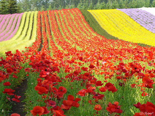
Many other flowers make Furano an attractive destination outside of the lavender season, as well. The main season for flower viewing takes place between June and September, although some flowers also bloom earlier and later than that. Flowers include rape blossoms, poppies and lupins from June, lilies from July and sunflowers, salvias and cosmos from August and September.

Poppy field in June
There are numerous flower fields of various sizes all across Furano. The best spot to view the lavender is Farm Tomita, whose lavender and flower fields with the Tokachi mountain range as backdrop are spectacular. The popular farm is free to enter and besides the flower fields has cafes and shops that sell a wide range of lavender related products. The farm naturally gets rather busy during the peak season.
In 2008, Farm Tomita opened a second farm, Lavender East to the public. Located about four kilometers east of Farm Tomita, Lavender East has by far the most spacious of all lavender fields in Furano, covering 14 hectares. Besides a shop, cafe and observation deck, the farm offers paid 15 minute rides on the "Lavender Bus" through the lavender fields.

Lavender East's Lavender Bus
Another popular farm for lavender and other flowers is the Flower Land Kamifurano. The farm's hillside location affords beautiful views of the Tokachi mountain range in combination with the flower fields. Among the attractions are rides through the fields on tractor pulled carts and hands on experiences such as lavender cutting and flower pressing.

An attractive way to travel between Furano, Biei and some of the lavender farms while enjoying the scenery, is the Furano-Biei Norokko train. The train operates on weekends from early June through late September and daily from late June through mid August, and stops at the temporarily constructed Lavender-Batake Station, a five minute walk from Farm Tomita.

Antelope Canyon is located near Page on Navajo Nation land, just outside Glen Canyon National Recreation Area and close to AZ 98 a few miles east of town (at milepost 299). Antelope is the most visited slot canyon in the Southwest, partly because it is easily accessible and by far the most publicized, and also since it is extremely beautiful, with just the right combination of depth, width, length, rock color and ambient light; many other slot canyons are deeper, narrower or longer, and some have rock that is even more colorful and sculptured, but here conditions are ideal.

Location
The seasonal stream of Antelope Creek flows into Lake Powell 3 miles east of Page in far north Arizona. Most of the watercourse is wide and sandy, but it forms two sections of slot canyon near the lake (Upper and Lower Antelope Canyon), separated by several miles of flat desert terrain. Both may be approached from AZ 98; the upper canyon (also known as Corkscrew Canyon) is reached at the end of a very sandy 2 mile 4WD track south of the road beginning near milepost 299, and it is this part which is usually visited. Lower Antelope Canyon extends between AZ 98 and the lake, and is reached by a short track northwards leading to a parking area from where the escorted tours depart.

Permit
To visit either part of Antelope Canyon is expensive. There is a fee of $6 for a standard permit required to enter Navajo territory, and an additional charge is due to the families who own the land around the canyons and regulate all access - the cheapest is currently (2015) $25 for the either the popular upper section or the longer lower canyon. This is the cost to travel to the canyons in a Navajo jeep; organized tours with a guide cost rather more, as do peak time visits (departing 10 am to midday). For the upper canyon the fee is paid to officials at the side of AZ 98 near the start of the track, and is now apparently only good for 2 hours, with longer visits costing an extra $5 per hour. The fee to enter the lower section is collected by attendants at the carpark near the canyon edge. These amounts will doubtless increase as the Navajo continue to exploit the popularity of the canyon.
 When approaching upper Antelope Canyon, there is no obvious clue as to its location. The trail seems to end at the base of a red sandstone plateau about 20 yards high, but the sight of an Indian jewelry stall soon indicates its position - the entrance is a narrow curved slit in the cliffs only a few feet wide. Once inside, the temperature drops as much as 20 degrees as the visitor enters one of the most beautiful of all natural formations. The sunlight filtering down the curved sandstone walls makes magical, constantly changing patterns and shadows in many subtle shades of color. Some sections of the canyon are wide and bright, while others are narrower and more cave-like, with no light reaching the sandy floor. After only 150 yards or so, the canyon becomes suddenly much shallower near the top of the plateau. It may take only 3 or 4 minutes to walk through, but the canyon is well worth the arduous trek or expensive journey required to get there. Pictures taken here adorn camera shops and photographic manuals throughout the world, and usually there will be many people waiting with tripods and light meters trying to compose the perfect shot, and grumbling when other people walk in front of their two minute exposure. There are other equally short but pretty narrows further upstream, though these are not open to visitors.
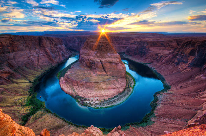
Lower Antelope Canyon
The lower canyon is longer and deeper than the upper section, but also slightly more challenging, requiring climbing down ladders in some places to descend several sheer drops. It was here that 11 people were drowned in a flash flood in August 1997, when water 50 feet deep from a thunderstorm 5 miles away swept through the canyon, eventually deepening it by 4 feet. Lower Antelope Canyon was closed for 9 months before reopening with improved safety features, and now all visitors must now be accompanied by a guide. Both parts of the canyon are still beautiful, but any sense of adventure or tranquility is long since gone - best to try one of the hundreds of other Southwest slot canyons for these qualities. The nearest alternative, free except for the standard Navajo hiking permit, is lower Water Holes Canyon, the section west of US 89.

The jewel in the crown of the country’s tourist attractions is Lake Malawi, “discovered” by the missionary-explorer Dr David Livingstone just over 150 years ago. Although totally landlocked, Malawi is not denied its “inland sea”. This vast body of freshwater fringed by beaches of golden sand is not only a scenic wonderland but it provides water sport opportunities for those looking for something beyond sun, sand and swimming. Its approximate dimensions are 365 miles north to south and 52 miles broad, hence the sobriquet: "the calendar lake". The Lake, in the north, is quite extraordinarily deep: 2300 ft/700 m, plunging well below sea level. This reflects the enormity of the natural faulting of the Great Rift Valley, which is the origin of the Lake. The width of the lake’s shorelands vary from nothing to over 25 kilometres (16 miles), the edge of the Rift Valley rising steeply in places and more gently in others.

Because of its rich fish harvest, the Lake plays an important part in the economy. Fishing villages are scattered along the shore and the traditional industry and practices are an attraction to visitors. Access to the Lake is possible along much of its length but it should be noted that it is usually necessary to take a short detour off the main roads in order to reach the beach. Despite the attraction the Lake has to settlement, there are long stretches of totally uninhabited golden sand lakeshore, lapped by crystal clear waters. Kayaking, sailing, snorkelling, scuba diving and water skiing are just some of the lake activities available to visitors. Journeys by lake range from the famous motor vessel the Ilala to sailing in an ocean-going yacht. Cruises into the upper reaches of the great Shire river are also possible.

Places to Stay
Good lodges are now to be found the length of the lakeshore, with a few collections in areas of particular beauty. Between Mangochi and Monkey Bay is a long line of wonderful beaches backed by a variety of accommodation. This Mangochi Lakeshore has the Lake’s greatest concentration of lodges and hotels. Monkey Bay is a functional port town, but round the headland is Cape Maclear and the Lake Malawi National Park, a UNESCO World Heritage Site and a veritable aquarium of tropical fish. In recent years, a number of high quality lodges have been built in this area. Senga Bay is another place where there are a number of lodges & hotels, and it benefits from being the closest point on the lake to Lilongwe. The stretch between the historic Nkhotakota and the sugar estate town of Dwangwa has a smattering of lodges. Another concentration is found on the Chintheche lakeshore, which has some stunning beaches. Nkhata Bay is primarily a port town, but has grown as a centre for independent travellers. The Northern Lakeshore beyond Chitimba has fewer lodges, and Karonga, an important archeological centre, is the only town of note before reaching Tanzania. Across the lake, into Mozambiquan waters, is Likoma Island. Not only does it have some beautiful beaches, and accommodation, but also a missionary-built cathedral the size of Winchester’s. A nearby stretch of the Mozambique shoreline, Manda Wilderness, is a 120,000 hectare community reserve of unspoilt wilderness and white sand beaches.
Lake Baikal: World's Largest, Deepest Lake
During the summer, when Lake Baikal is full of melted ice from the Siberian mountains, it is sometimes possible to see more than 130 feet (39 m) down.
Credit: AnSTop | Shutterstock
Lake Baikal is the largest freshwater lake in the world (by volume) and the world's deepest lake. Somewhat crescent shaped, it is in the southern Siberia area of Russia. In 1996 it was declared a UNESCO World Heritage Site.
 "Lake Baikal is the oldest lake in the world. It is home to approximately 1,700 to 1,800 endemic plant and animal species," said Jennifer Castner of Pacific Environment's Russia program. Additionally, it holds 20 percent of the world's fresh water, due to the lake's depth.
By the numbers
Volume: 5,521 cubic miles of water (23,013 cubic kilometers). This volume is approximately equivalent to all five of the North American Great Lakes combined, according to Geology.com.
Advertisement
Maximum depth: 5,354 feet (1,632 meters). Its lowest point lies more than 4,000 feet (1,219 m) below sea level, according to Smithsonian magazine.
Average depth: 2,442 feet (744 m), according to Smithsonian magazine.
Surface area: 12,248 square miles (31,722 square km), according to Smithsonian magazine. This area puts it in seventh place worldwide in terms of surface area, according to Geology.com.
Length: 397 miles (640 km), according to Lake Baikal.org.
Maximum width: 49 miles (79.5 km), according to Baikal World Web.
Average width: 29 miles (47 km), according to Baikal World Web.
Minimum width: 16 miles (25 km), according to Baikal World Web.
Coastline area: 1,300 miles (2,100 km), according to Lake Baikal.org.
Lake Baikal location
Lake Baikal is located in south-central Russia near the Mongolian border. The largest nearby city is Irkutsk. Lake Baikal has historically played a large role in the Russian imagination. It represents the unspoiled beauty of Russia and is sometimes referred to as the Sacred Sea. Lake Baikal plays a central part in many local creation myths and appears throughout Russian folklore, according to Baikal Nature. Lake Baikal attracts more than 500,000 tourists a year, according to the Siberian Times.

Though it is in southern Siberia, the lands around Lake Baikal are generally warmer than the rest of the area because large bodies of water have a moderating force, according to LakeBaikal.org.
Olkhon Island is the largest island on Lake Baikal. About 1,500 people live there.
Olkhon Island is the largest island on Lake Baikal. About 1,500 people live there.
Credit: marinya Shutterstock
Lake Baikal features
There are 27 mostly uninhabited islands in Lake Baikal, according to Lake Baikal.org. The largest is 45-mile-long (72 km) Olkhon, on which there are villages. About 1,500 people live there.
More than 300 streams and rivers feed into Lake Baikal, but the Angara River is the only outlet. It carries out about 60 cubic km (15.8 trillion gallons) of water per year into the Yenisei River. Eventually the water makes its way to the Arctic Ocean.

The Selenga River is the largest source of water coming into Lake Baikal. Flowing north from Mongolia, it contributes nearly 50 percent of the lake's water. Like Lake Baikal, the Selenga Delta is internationally recognized for its biodiversity and importance, according to the Ramsar Convention.
Lake Baikal is the only very deep lake to have oxygenated water at its lowest depths, like the ocean, according to a 2009 article in BioScience. Additionally, the earth under Lake Baikal is heated. The cause of the heat is unknown.
Lake Baikal is considered one of the clearest lakes in the world, according to CNN Traveler. During the summer, when the lake is full of melted ice from the Siberian mountains, it is sometimes possible to see more than 130 feet (39 m) down. The stunning clarity is the result of the melted ice's purity, plankton that eat floating debris and a lack of mineral salts in the lake.
Lake Baikal may be warmer than other parts of Siberia, but in the winter it still gets very cold. The average air temperature in winter is minus 6 F (minus 21 C). Despite its size, Lake Baikal freezes over in the winter and usually melts in May or June, according to LakeBaikal.org. The ice can be up to 6 feet (2 m) thick. In the summer, the average air temperature is 52 F (11 C). The water temperature in August is around 50 F (10 C).
The nerpa is the world's only exclusively freshwater seal. It is only found in Lake Baikal.
The nerpa is the world's only exclusively freshwater seal. It is only found in Lake Baikal.
Credit: Andrei Gilbert Shutterstock
Lake Baikal history
At least 25 million years old, Lake Baikal is the oldest lake in the world. It and the surrounding mountains were formed by the Earth's crust fracturing and moving. According to Baikal World Web, it was probably originally a riverbed, but tremors and fractures in the Earth's crust increased the size and widened the space between the shores. Parts of the Baikal basin developed at different times throughout the Tertiary Period (66 million to 2.6 million years ago). Melting glaciers also increased the water levels.

It is likely that a series of lakes, similar to the Great Lakes, developed first and then united in the Pliocene Epoch (5.3 to 2.58 million years ago), according to Baikal World Web. There are several theories about what could have caused the unification, including sinking earth, falling rocks, erosion and earthquakes. Likely, it was a combination of all factors.
Lake Baikal is in a rift valley and up to 2,000 earthquake tremors are detected each year. The earthquakes deepen the lake and increase its size. For example, an 1862 earthquake resulted in the creation of Proval Bay, according to Irkutsk.org.
According to the Baikal Center, some geophysicists think that Lake Baikal is an ocean being born. The shores drift farther apart by 2 cm (0.78 inches) a year, the same rate at which Africa and South America drift apart.
Indigenous communities have lived around Lake Baikal since at least the sixth century B.C., though they visited long before that. It was the site of a battle in the Han-Xiongu War (133 B.C. to A.D. 89). Local legend holds that Jesus visited Lake Baikal, according to Smithsonian magazine. The first European to visit Lake Baikal was the Russian Kurbat Ivanov in 1643. Russia expanded its territory to include Lake Baikal during the 17th-century Russian conquest of Siberia.
Lake Baikal ecosystem
According to the UNESCO World Heritage Commission, Lake Baikal is sometimes called the "Galapagos of Russia" because of its exceptional biodiversity and importance to evolutionary science. The age, isolation and deep oxygenated water of Lake Baikal have resulted in one of the world's richest freshwater ecosystems.
About 80 percent of the more than 3,700 species found at Lake Baikal are endemic, meaning they are found nowhere else on Earth. Probably the most famous of these species is the nerpa, the world's only exclusively freshwater seal. Scientists are unsure how the nerpa came to Lake Baikal and evolved, but they suspect the seals might have swum down a prehistoric river from the Arctic, according to LakeBaikal.org. Other endemic species include the oily, scaleless golomyanka fish and the omul, a white fish that is one of Lake Baikal's most famous dishes.
Other land-based species around Lake Baikal include bears, reindeer, elk, wild boar, Siberian roe deer, polecats, ermine, sable and wolves. American minks, imported from Canada, also live around Lake Baikal, according to Baikal World Web.
More than 50 species of fish live in Lake Baikal, according to Baikal World Web. Aquatic invertebrate species include more than 100 species of flat worms, more than 700 species of anthropods (insects, arachnids and crustaceans) and more than 170 species of mollusks. These invertebrates all help purify the water.
There are dozens of tree species, including cedar, fir and spruce, growing in the Lake Baikal area. Some of the trees are up to 800 years old. The Angara pine tree is native to the area, according to Baikal World Web.
Lake Baikal is in southern Siberia. The closest city is Irkutsk
Lake Baikal is in southern Siberia. The closest city is Irkutsk
Credit: Peter Hermes Furian Shutterstock
Threats to Lake Baikal
As Russia and Mongolia have become increasingly industrialized and tourism has increased, Lake Baikal has faced more and more threats to its environment. Additionally, climate change is threatening its ecosystem. Water temperatures and ice cover have already changed, according to BioScience.
Castner described several of the dangers facing Lake Baikal. The biggest threat is probably the "huge problem with algae on the lake and government failure to develop an adequate response to it," she said. Massive green algae blooms plague bodies of water like the Great Lakes, but for a long time Russian scientists assumed that Lake Baikal was too big to be affected by them. But since at least 2008, Spirogyra algae blooms have appeared on the bottom of the lake, according to National Geographic. The algae blooms are found in shallow water and wash up on shore, where they emit a horrible stench.
The algae are toxic to other species. The algae have damaged water snails, sponges, fish and crustaceans — which pass the toxins along to people, according to the New York Times.
"The algae blooms are presumably caused by temperature changes, climate changes and excessive runoff into the lake from agricultural sewage and industrial sewage," Castner said. The concentration of algae in shallow water and the fact that algae blooms have historically appeared in areas with untreated sewage suggest that untreated sewage is a significant contributing factor to the problem. "But," Castner noted, "no proper study has been done to definitively determine the cause of the algae blooms."
She added, "There's a huge increase in tourism on shores all around the lake and there's not a real understanding of how that's affecting the lake." Local communities do not have adequate waste management systems relative to the number of tourists. But at least one effort to healthily manage tourists at Lake Baikal is succeeding: the Lake Baikal Trail, which will surround the entire lake, is being built slowly but surely.
"Another serious threat is a proposed series of dams on the Selenga River and its tributaries," Castner said. Mongolia is actively planning to build the dams in order to obtain energy. But the dams would seriously reduce the amount of fresh water flowing into the lake. In addition to lowering lake levels, the dams could change the level of sediment entering the lake and lessen the quality of breeding sites for birds and fish, as well as and block their migration routes, according to The New York Times.

Lake Baikal has successfully met environmental challenges in the past. In 2006, activists were able to get the government to completely reroute an oil pipeline. "It would have crossed into the lake's watershed in the north and come within 800 meters of the lake. It would have had devastating impacts," Castner said.
From 1966 to 2008, the Baikalsk Paper and Pulp Mill operated off the shores of Lake Baikal. "Paper-making and pulp-processing are water-intensive processes that involve using water and then dumping it," Castner explained. The dirty water was dumped into the lake, which resulted in a 12-square mile environmentally dead zone in the shallows. Community-led opposition led to valid studies of the problem and, though the government repeatedly delayed it, the mill was eventually shut down. Today, the environment in the water is slowly recovering. But the plant has not been demolished, the land around it has not been restored, and the chemicals around it have not been removed. The town is struggling economically.


